Understanding the Journey — Why It Is More Complex Than It Looks
Before distances and routes, here is the most important thing to understand about getting from Kedarnath to Tungnath:
There is no direct road or trek connecting the two temples.
There is no direct road from Kedarnath to Tungnath. The full journey breaks into four parts: a 16 km downhill trek from Kedarnath to Gaurikund, a short taxi ride to Sonprayag, an 80 km road drive to Chopta, and finally a 4 km uphill trek to Tungnath.
The straight-line distance between Kedarnath and Tungnath is about 30 kilometres. However, the journey isn’t as simple as following a direct path. The geography and lack of road access require a mix of trekking and driving.
Think of it this way — Kedarnath sits in the Mandakini river valley and Tungnath in the Alaknanda river system. Between them lies a complex series of ridges and river gorges that make a direct route impossible. You must descend from one side, cross the mountain system by road, and ascend the other. This is not a disadvantage — it is the nature of Himalayan geography, and the road journey between the two is beautiful.
Covering approximately 80–90 km by road, this path takes you from the steep Mandakini valley to the high-altitude meadows of Chopta.
The Distance — All Numbers in One Place
| Segment | Distance | Mode |
|---|---|---|
| Kedarnath Temple to Gaurikund | 16 km | Trekking (downhill) |
| Gaurikund to Sonprayag | 5 km | Shared jeep / taxi |
| Sonprayag to Guptkashi | ~35 km | Road |
| Guptkashi to Ukhimath | ~15 km | Road |
| Ukhimath to Chopta | ~30 km | Road |
| Chopta to Tungnath Temple | 3.5 km | Trekking (uphill) |
| Total (approx.) | ~80–90 km by road + 20 km trekking |
Straight-line distance between temples: approximately 30 km By combined road and trek: approximately 100 km total.
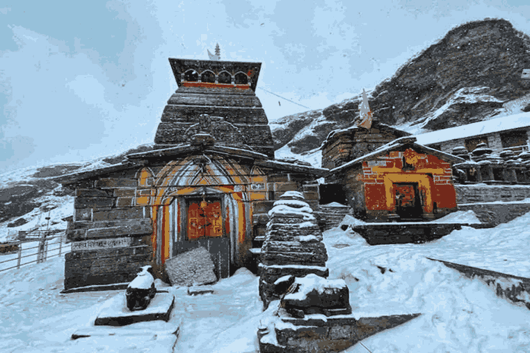
Tungnath Temple — What You Find at the Top
Tungnath is one of the Panch Kedar temples and at an altitude of 3,680 metres, it is the highest Shiva temple in the world. It is located on the Chandranath parvat in the Rudraprayag district of Uttarakhand.
The temple itself is smaller than Kedarnath — considerably so. It is a small shrine and can accommodate only ten people in the sanctum. The sanctum contains the sacred black stone of one foot high, denoting the form of arms of Lord Shiva.
The mythology of Tungnath is part of the Panch Kedar story — the journey of the Pandavas seeking Lord Shiva’s forgiveness after the Mahabharata war. Lord Shiva disguised himself as a bull to escape the Pandavas. The places where the parts of the bull were found are now renowned Shiva temples. Each one is identified with a part of his body: the navel and stomach at Madyamaheshwar, the hump at Kedarnath, the arm at Tungnath, the face at Rudranath, and his hair at Kalpeshwar.
So at Tungnath, you are at the place where Lord Shiva’s arm was discovered — the third in the Panch Kedar circuit. The temple’s stone construction and intimate size create an atmosphere that is perhaps even more immediately personal than Kedarnath’s larger setting. You stand very close to the sacred idol. The mountains are right there. The wind comes directly off the glaciers above.
The temple also houses the images of the Pandavas and silver plaques of other four Kedar shrines. At the entrance there is a Nandi stone image facing towards the sanctum.
Chandrashila Peak
Just 1.5 km above Tungnath Temple, the Chandrashila Peak stands at around 4,000 metres, offering one of the most breathtaking 360-degree panoramic views in Uttarakhand.
Although the final 1.5 km climb is often called optional, it is something most travelers consider unmissable. The trail is steep but short, and usually takes about 45 minutes to 1 hour from Tungnath. If you have completed the Tungnath trek, this stretch is challenging but absolutely manageable.
The real magic happens at the summit. At sunrise, peaks like Trishul, Nanda Devi, and Chaukhamba slowly light up in golden hues, creating a view that feels almost spiritual. The silence, the cold mountain air, and the endless Himalayan ranges make it a moment of pure connection — not just with nature, but with yourself.
On a clear day, you can even spot Kedarnath Dome in the distance — a reminder of the journey you began at Kedarnath, bringing your entire travel experience full circle.
For the best experience, start early from Chopta (around 5–6 AM). This allows you to reach Chandrashila by 9–10 AM and return comfortably by afternoon, giving you enough time to relax or continue your onward journey.
Best Time to Travel
Both Kedarnath and Tungnath temples remain closed from November to April every year. Heavy snowfall makes the trek routes and mountain roads completely inaccessible during these months.
| Season | Conditions | Recommendation |
|---|---|---|
| May to June | Temples open, rhododendrons in bloom, clear skies | Excellent — best for flowers and clear views |
| July to August | Monsoon rains, landslide risk on Sonprayag-Chopta road | Avoid if possible |
| September to October | Post-monsoon clarity, best views, fewer crowds | Best overall — highly recommended |
| November | Temple closure begins, roads increasingly risky | Check dates before planning |
| December to April | Both temples closed, snow-blocked roads | Not accessible |
September to October: Post-monsoon season is arguably the best time. Skies are clear, trails are less crowded, and the Himalayan views are stunning.
Monsoon warning: The road from Sonprayag to Chopta via Ukhimath is prone to landslides in monsoon. Even one night of heavy rain can block the route for 24–48 hours.
Suggested Itinerary — Kedarnath to Tungnath in 4 Days
| Day | Route | Key Activities |
|---|---|---|
| Day 1 | Kedarnath darshan | Morning temple visit, explore Bhimshila and Bhairav Temple |
| Day 2 | Kedarnath → Gaurikund → Sonprayag → Ukhimath | Start descent by 5 AM, Omkareshwar Temple, overnight in Ukhimath |
| Day 3 | Ukhimath → Sari → Deoria Tal → Chopta | Morning Deoria Tal trek, lunch, reach Chopta evening |
| Day 4 | Chopta → Tungnath → Chandrashila | Early start, Tungnath darshan, Chandrashila summit, return |
This four-day plan is comfortable, unhurried, and includes the hidden stops that make this journey exceptional rather than merely good.
Conclusion — A Journey Greater Than Either Temple Alone
The journey from Kedarnath Temple to Tungnath Temple is more than just travel — it is an experience of devotion, nature, and self-reflection. Kedarnath leaves you with its power and grandeur, while Tungnath offers peace, silence, and breathtaking views from Chandrashila Peak. Together, they complete a truly special Panch Kedar journey, blending spirituality with the raw beauty of the Himalayas. As you travel, take it slow and explore places like Triyuginarayan Temple, Deoria Tal, and Chopta along the way. The mountains will guide you — one step at a time.
Har Har Mahadev
