Skip to content

Kalpeshwar Urgam Valley to Rudranath Trek Uttarakhand 2023

6 Days

As Kalpeshwar to Rudranath Trek is one of Uttarakhand’s less popular pilgrimages, its natural beauty has been retained unaltered. The trail travels through thriving communities that rely primarily on vegetation for survival. The hike from Kalpeshwar to Rudranath offers a virgin trail with several possible approaches. Although Helang is where most people begin this circuit (Kalpeshwar to Rudranath), Saggar and Mandal in the vicinity of Kalpeshwar are also viable starting points.

The Himalayan region of Garhwal is rich in sacred sites, deep canyons, lush meadows, and dense woods. Hindu devotees frequently travel to Kalpeshwar, Rudranath, and Tunganath, three of the holy and revered “Panch Cedars,” for religious pilgrimages.

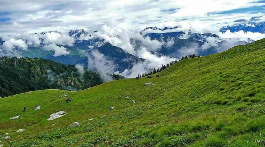
The path that leads to these uncomplicated but breathtaking locations provides sweeping vistas of the Himalayan mountain ranges. The road is actually a trekker’s paradise, drawing travelers from all over the world in search of adventure and enlightenment.

Mythological Background Of Kalpeshwar – Rudranath

The Pandavas wished to go see Lord Shiva after the Mahabharata War ended. This is the mythological background of Kalpeshwar-Rudranath. Yet Lord Shiva was enraged and avoided them since, regardless of the justification, they had slaughtered their brethren in battle. Lord Shiva disguised himself as a huge bull and wandered around to deceive them. Bhim pursued him because he thought he may be Lord Shiva. Digging a hole, Lord Shiva entered the earth. Eventually, numerous pieces of Lord Shiva’s body were found in different locations; these locations are now known as the Panch Kedar temples, which include Kedarnath, Madhmaheshwar, Tungnath, Rudranath, and Kalpeshwar. Moreover, Pashupatinath in Nepal is thought to be the sixth cedar.

The final and most accessible temple on the revered Panch Kedar Circuit is Kalpeshwar. The only temple that is open all year round is Kalpeshwar. The generally visible swayambhu jata, or hair of Shiva, is present in the Kalpeshwar Temple in the form of a protruding rock. A small stream that emerges from a stone within the boundaries of the sanctuary collects water in a rocky depression to form Amrit Kund, also known as Nectar Lake.

Quick Facts About Kalpeshwar Rudranath Trek:

Meal Types: Vegetarian

Kalpeshwar Rudranath Trek Duration: 11N/12D

Kalpeshwar Rudranath Trek Total Distance: 84 km

Temperature Range: March to May: 150 to 300C, November to December: 80 to -20C.

Kalpeshwar Rudranath Trek Difficulty Level: Moderate

Itinerary

Drive - 251 km Alt -2000 m Stay - Homestay

Devprayag, Rudraprayag, and Karnaprayag are the three main confluences that are traversed on the route from Rishikesh to Helang. Take a bus or shared taxi up to Joshimath in the early morning, but make sure you get off at Helang. You must reserve a taxi for the 12-kilometer bumpy travel from Helang to Urgam.

Following arriving in Urgam, we will settle into a homestay and have a break. If time allows, you can also visit Village and speak with residents there.

Trek - 14 km Alt - 2400 Mt | Stay Camp

Trek from Urgam to Kalpeshwar in the early morning hours. From Urgam, it takes more than an hour to get to Kalpeshwar Temple. You can also go to the Dhyan Badri shrine in Devgaon. Start the hike to Dumak after Kalpeshwar's morning aarti.

You'll reach a pass that will allow you to see the other side of the valley after three hours of hiking. Then, the trail will be followed with a steep decline. After taking a short break in a settlement you come across, continue your journey to the bridge. The moment you cross the bridge, a temple will be seen. From here, it takes another hour to get to Dumak. A lonely settlement called Dumak is located at a height of 2400 meters above sea level.

Trek - 13 km Alt - 3400 m Stay Camps
By walking around the village's right side, you can get across it. saunter to the bridge. From Dumak, it takes less than an hour to go to this bridge. The remainder of the walk is primarily an uphill ascent. Toli Bugyal is a pleasant but very unsettling-looking campsite that the trail passes through. Although Toli Tal is located in Toli Bugyal, its water is unfit for consumption or cooking. The elevation of Toli Bugyal is 2850 meters above sea level. After taking a break here for lunch, head over to Panar Bugyal.
In Panar Bugyal, a difficult ascent lasting another three hours through the pristine forest begins. This tiny but beautiful meadow is located 3400 meters above sea level. This is the prettiest campsite ever.

Trek - 7 km Alt - 3600 m | Stay Camps

Most likely, this day will be the most fruitful of the entire hiking section. The Himalayas on your left will welcome you with open arms after around 15 minutes of the hike. A thin ridge then follows, leading to Pitradhar, the trek's highest point (4000 mts). A modest temple called Pitradhar has bells and prayer flags hanging from the ceiling. From here, the trail primarily descends while passing through Panch Dhara. The majority of tourists attempt to trek back to Panar on the same day because there is very little camping space at Rudranath. Rudranath is a really special location with beautiful views all around. The location of the building is 3600 meters above sea level.

Trek - 16 km | Stay Hotel or Home Stay

Go on to Naola Pass after ascending towards Pitradhar. To get to Anusuya Devi Temple, the trip continues through the pristine meadows of Dhanpal Bugyal and Hansa Bugyal. The local villagers retain a particular place in their hearts for this temple, which is known as the last resort for childless couples.

Trek - 8 km | Stay Hotel

Trekking stops at this roadhead after the descent to Mandal from the Anusuya Devi Temple. To catch an early bus or cab the following morning, travel from Mandal to Gopeshwar on the same day. At Sagar Village, our trek services come to an end.

You can send your enquiry via the form below.

Kalpeshwar Urgam Valley to Rudranath Trek Uttarakhand 2023